|
|
|
|
|
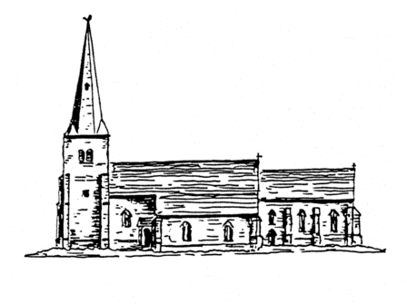
What did the church look like The earliest known illustrations of Flawford church comes from a tapestry map of Nottinghamshire made in 1632. The map was almost certainly based on Speed’s map of Nottinghamshire and it was published din 1610. This is evident as both have misspelt Flawford and Plumtree was omitted from both maps. The second drawing was by Mr Carver of Leicester, who was a native of Ruddington. His drawing comes from Thosby’s additions to Dr Thoroton’s ‘Antiquities of Nottinghamshire’. This picture is said to have been drawn from memory after the demolition of the church in 1773 and 1779 and therefore cannot be expected to be an accurate drawing. However, there is a striking resemblance between Carver’s drawing and the illustrations form the tapestry map. It is most unlikely that Carver would have seen the tapestry as the latter was privately owned and not accessible to the public. The excavation helped to provide an accurate ground plan of the church and the position of the buttresses and doors. It also gave some idea of the dating of the various stages which would influence the architectural style. The last drawing is therefore using Carver’s sketch and fitting it to the known ground plan and hinting at the possible architectural styles.
|
||
|
Mid Bronze Age Building the Church phases 1-5 Building the Church phases 6-10 The Chantry Chapels of Flawford Where to find the evidence The Flawford Museum The Hermitage Museum Glossary Contact us Site Map Links
|
||